Yr Wyddfa plummets to -9C amid Storm Chandra ice and flood alerts

 Tony Ellis
A yellow weather warning for ice has been issued for much of Wales, following travel disruption and flood warnings due to Storm Chandra.
The ice warning, which covers parts of north, mid and south Wales, comes into effect at 00:00 GMT on Wednesday and will be in place until 10:00.
The Met Office warned temperatures would fall below freezing, with some disruption possible.
"After the recent wet weather, icy patches are likely to develop on some untreated surfaces," the forecaster said.
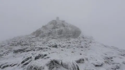
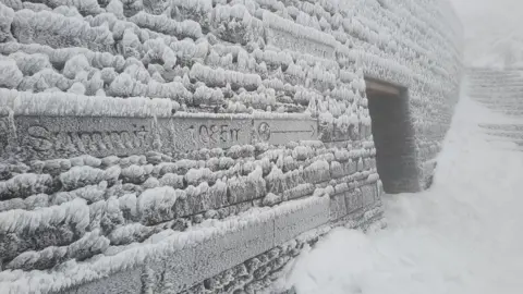
It comes as images taken at the summit of Wales' highest mountain, Yr Wyddfa, show extreme conditions as the temperature plummeted to -9C (16F).
The areas covered by the ice warning are:
- Blaenau Gwent
- Caerphilly
- Carmarthenshire
- Conwy
- Denbighshire
- Flintshire
- Gwynedd
- Merthyr Tydfil
- Neath Port Talbot
- Powys
- Rhondda Cynon Taf
- Wrexham
 Tony Ellis
Storm Chandra has brought travel disruption and a number of flood alerts across Wales, as well as a yellow wind and rain warning.
It is the third major storm to hit the UK this month after Goretti and Ingrid, which caused widespread damage and disruption.
There have been outbreaks of heavy and persistent rain and gales on Tuesday, with a "small chance" of gusts up to 80mph (129km/h) in parts of Pembrokeshire, the Met Office said.
The M48 Severn Bridge was closed earlier but reopened, and there are flood warnings and flood alerts in place across the country.
Chandra also brought south to south-westerly winds, with gusts of up to 60mph (97km/h) inland and 70mph (113km/h) along coasts.
An alert for rain was in place until 10:00 GMT on Tuesday, covering much of south and mid Wales, while a wind alert is in place for parts of south west Wales until 16:00 on Tuesday.
Forecasters predicted widespread rainfall of between 20mm (0.8in) and 30mm (1.2in), in the worst-hit areas, including Bannau Brycheiniog, also known as the Brecon Beacons, seeing up to 80mm (3.2in).
Rain falling on previously saturated ground means the risk of flooding of homes and businesses has increased, alongside associated travel delays, the Met Office said.
Gwent Police said the A40 was flooded between Abergavenny and Raglan.
Irish Ferries cancelled all sailings between Pembroke and Rosslare and most between Holyhead and Dublin due to the storm, with Stenaline cancelled all of their ferries from Anglesey and Pembrokeshire.
 Met Office
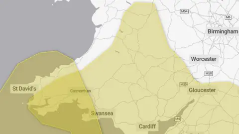
The yellow rain warning for Storm Chandra covered the following areas:
- Blaenau Gwent
- Bridgend
- Caerphilly
- Cardiff
- Carmarthenshire
- Ceredigion
- Merthyr Tydfil
- Monmouthshire
- Neath Port Talbot
- Newport
- Pembrokeshire
- Powys
- Rhondda Cynon Taf
- Swansea
- Torfaen
- Vale of Glamorgan
The yellow wind warning during Storm Chandra is in place in the following areas in south west Wales:
- Carmarthenshire
- Ceredigion
- Pembrokeshire
- Swansea
Those whose properties are at risk of flooding due to the weather alerts are advised to prepare a flood plan and an emergency flood kit, while drivers are urged to check road conditions or public transport timetables.
The Met Office also advised people to consider gathering torches and batteries, a mobile phone power pack and other essential items in case of power cuts.
Traffic Wales warned drivers to cut their speed in heavy rain and leave plenty of distance between their vehicle and the one in front.
They also urged anyone coming across floodwater on a road to find an alternative route if they are not sure of its depth.