Ice and snow warnings as another blast of Arctic air sweeps across the UK

 Getty Images
Another blast of Arctic air is set to sweep across the UK this week, bringing frost, ice and snow warnings.
Yellow weather warnings for snow and ice have been issued by the Met Office for much of Scotland as well as northern and eastern England from Monday afternoon. Periods of sleet and snow are expected through Monday evening and overnight with the potential for travel disruption.
A separate yellow ice warning is in force for all of Northern Ireland from 20:00 GMT on Monday until 10:00 on Tuesday.
The Met Office warned commuters to remain vigilant due to the risk of black ice and slippery conditions.
The yellow warnings include:
- Snow and ice for northern Scotland from 15:00 GMT on Monday through to 10:00 Tuesday
- Ice for southern Scotland and much of northern and eastern England from 18:00 on Monday to 10:00 Tuesday
- Ice for all of Northern Ireland from 20:00 GMT on Monday until 10:00 on Tuesday.
Several snow and ice warnings were in place over the weekend as frosty Arctic air spread across the country.
Monday will bring blustery showers and a few brighter spells for much of the UK, with wintry showers continuing across Scotland and snow settling over higher ground.
By Monday night, colder Arctic air will spread south, lowering snow levels across Scotland and increasing the risk of ice. Some snow showers are also possible across the North York Moors.
Tuesday is expected to be mostly dry and sunny for many, but with temperatures only reaching 3C (37.4F) to 6C (42.8F) and a brisk northerly wind, it will feel colder - particularly in eastern areas where wind chill could make it feel close to freezing.
Temperatures are set to fall close to freezing for most of the UK on Wednesday morning.
In parts of northern and north-east Scotland, temperatures could fall to -8C and -10C. Further ice warnings may come into force.
Weather conditions will become more unsettled again on Wednesday with a band of rain pushing in from the south and west. This could bring a mix of rain, sleet and hill snow, according to the Met Office. The forecaster said the system is being monitored closely with the potential for further snow warnings.
Later in the week, conditions are expected to turn drier and milder.
 Getty Images
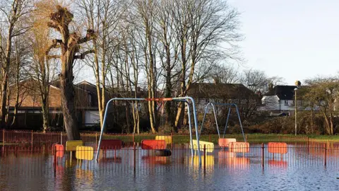
Meanwhile, 70 flood warnings and 195 flood alerts have been issued by the Environment Agency across England - concentrated in the south and the Midlands - following a long spell of wet weather.
Jonathan Day, flood duty manager at the Environment Agency, said more than 24,000 homes and businesses have been protected but about 330 have been flooded.
With further heavy rain forecast for southern England and South Wales on Wednesday, and the ground already saturated, more flood warnings or alerts could be issued.
Four flood alerts were issued by Natural Resources Wales on Monday for the upper Severn catchment in Powys, the Vyrnwy catchment, the lower Severn catchment in Powys and south Pembrokehsire.
An hour-by-hour forecast is available on the BBC Weather website and app.