Storm Chandra brings more heavy rain to South West

 Gilly Gabben
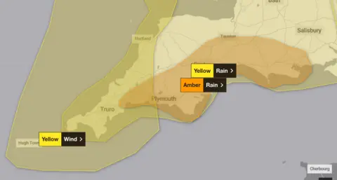
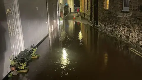
An amber weather warning for rain has been issued for parts of south-west England alongside yellow weather warnings for both wind and rain.
The amber warning, affecting parts of Devon, Cornwall and Dorset, has been put in place from 17:00 GMT on Monday until 09:00 on Tuesday.
The Met Office forecast 30mm (1.2in) to 50mm (2in) of rain could fall during Storm Chandra, with some areas of higher ground seeing 60mm (2.4in) to 80mm (3.1in).
The amber alert follows a yellow warning for rain already in place from 13:00 on Monday until 10:00 on Tuesday. There is also a Met Office yellow weather warning for wind for Cornwall, Devon and the Isles of Scilly from 05:00 until 16:00 on Tuesday.
The Met Office said south to south-westerly winds, associated with Storm Chandra, would become very strong during Tuesday morning.
It said there would be peak gusts of 50mph (80.46km/h) to 60mph (96.56km/h) inland.
It added exposed coasts could see 60mph to 70mph (112.65km/h) and there was a small chance of gusts up to 80mph (128.74km/h) for parts of the Isles of Scilly.
 Met Office
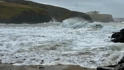
The latest warning comes as a massive clear-up continues after Storm Ingrid hit Devon and Cornwall.
A sea wall protecting the railway line at nearby Dawlish partially collapsed and train services were suspended between Exeter St Davids and Plymouth on Saturday.
The Met Office said there could be delays or cancellations to train and bus services and heavy rain was likely to bring flooding in places.
It said there could also be power cuts and loss of other services to some homes and businesses.
Damaged bridges
Great Western Railway (GWR) said the train lines between between Par and Newquay and between Liskeard and Looe were closed due to flooding.
It said disruption was expected until the end of the day and rail replacement transport would be in place.
It said heavy rainfall during December combined with high tides resulted in water levels at several bridges along the branch line being above the level which allowed them to run trains safely.
It added this had caused some damage to bridges, which would require repairs.
GWR said disruption was expected until the end of the day on Wednesday.
Chris Wilding, flood duty manager at the Environment Agency (EA), said significant surface water flooding impacts would be "probable" in the South West during Storm Chandra.
"There is a significant risk of river flooding impacts too," he said.
"Environment Agency teams are out on the ground, taking action to reduce the impact of flooding and support those communities affected."
He urged people not to drive though flood water as it was often deeper than it looked and just 30cm (1ft) of flowing water was enough to float your car.
 Environment Agency
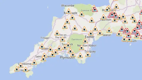
On Monday afternoon, EA issued flood warnings and alerts for parts of Devon, Cornwall and Dorset.
Warnings have been issued in locations including the Upper Frome in Maiden Newton and Christchurch harbour.
Meanwhile, flood alerts have been issued in dozens of areas including the Lower Exe, Exmoor Rivers and the south Cornwall coast from Land's End to Lizard Point.

Emma Wilson, a resident in Torcross, said Storm Ingrid on Saturday was "just devastating all the way through the village".
She added: "There was always talk that they're never really going to repair the road if it ever went again... but it's a main line into the village."
Bonnie Lincoln lives on the seafront in Torcross and has workmen boarding up her house again.
She said: "Today it's just a case of battening down again and getting out.
"Friday night, I was the most terrified I've ever been."
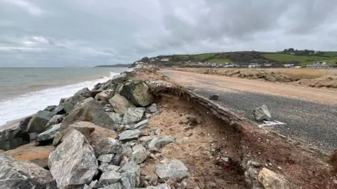
Rob Richards, deputy director of highways at Devon County Council, said: "The whole of the south coast has taken a real battering.
"We're just assessing the whole extent, but there's a lot of work to be done right across the county."
Joel Ninnes, RNLI water safety manager, said they were bracing for the impact of Storm Chandra.
He said: "With the ground already sodden, cliff edges are unstable and coastal structures already undermined by recent strong winds and rough seas.
"Our advice is to keep well away from cliff edges and sea fronts.
"If you do plan to visit the coast or a waterside location, we urge you stay a safe distance from the water as conditions could knock you off your feet or wash you into the sea and keep a safe distance from wet and slippery edges, let someone know where you are going and carry a means of calling for help."
 Andrew Wallbank
Cornwall Council said on social media at about 11:15 flooding was "likely due to already saturated ground".
The authority said: "Flood alerts are in place in some areas. If you live in a flood-risk area, you should take steps now to protect your property.
"Never walk or drive through flood water. Travel disruption is likely and people are advised to take extra care."
Plymouth City Council warned further delays and cancellations to train and bus services were likely and spray and flooding could lead to difficult driving conditions, as well as some closures.
It said fast flowing or deep floodwater was likely in places, along with possible landslides in "prone locations".
The authority said the Barbican lock gates and Mount Batten breakwater were closed and flood boards would remain in place on the Barbican until Wednesday.
The council added: "Please take extra care on the roads if you must travel, as well as in low-lying, seafront and coastal areas.
"Our highways team are out inspecting and clearing culverts and will be on standby to respond to any urgent issues that arise."
'Financial impact'
Torbay Council said its teams responded to a range of incidents caused by Storm Ingrid and it did not yet know the full financial impact of the storm, adding it may take some time to "fully assess".
The council said: "As many of our frontline teams were working throughout the weekend, there may be some short delays to routine tasks.
"To help keep everyone safe, please do not cross any safety fencing or barriers.
"These are in place to protect you until repair or remedial work can be completed."

Robert Phipps, who runs an ice cream shop business on Teignmouth's seafront, believes Storm Ingrid had caused thousands of pounds worth of damage.
He said he had not been able to examine the full extent of the damage at his business, but he anticipated there would be issues caused by flooding to electrical equipment including ice cream machines worth £24,500.
"Seeing is believing and you had to be here to witness the ferocity of the storm," Phipps said.
"It was a fantastic spectacle to see but very frightening as well."
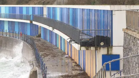
Beach huts in the Meadfoot area of Torquay also sustained damage as the storm hit the area over the weekend.
Maggie Matthews, who owns one of the huts, said the damage to some of the properties had been "horrendous".
She said: "I've never seen anything like it before with waves coming over the top of the cafe."
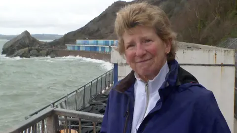
Matthews said she was concerned about Storm Chandra because of damage which had already been caused to the beach huts.
"The worry is it could cause a lot more damage," she said.
"The council and harbour facilities have been fantastic - we had emails and they put safety measures in place."